
Australian geological formations are more than just landscapes—they are ancient storytellers, chronicling the evolution of Earth across billions of years. From soaring sandstone monoliths like Uluru to the limestone sea stacks of the Twelve Apostles, these formations not only shape the terrain but also the cultural, ecological, and scientific identity of Australia. The country boasts some of the world’s oldest rocks, like those in the Hamersley Range, which are over 2.5 billion years old. These sites are vital for understanding planetary history, and many are protected in national parks under organizations like Parks Australia and Geoscience Australia, ensuring they remain untouched for future generations.
In Western Australia, visitors can marvel at the beehive-like domes of the Bungle Bungle Range, part of Purnululu National Park. These formations, sculpted by wind and rain over 350 million years, highlight the dynamic forces shaping the Australian continent. Equally stunning are the Pinnacles Desert, where thousands of limestone spires stand in eerie silence, attracting over 250,000 tourists annually according to Australia.com. Sites like Wave Rock, with its ocean-like granite curve, remind us how geology creates visually surreal experiences that also carry cultural significance for Indigenous Australians—recognised and preserved through efforts by organizations such as AIATSIS.
In South Australia, the Flinders Ranges hold the oldest known fossils of complex life forms, the Ediacaran biota. These fossils, over 600 million years old, have reshaped our understanding of evolution and are actively studied by researchers through institutions like The University of Adelaide. Moving inland, the vast Lake Eyre Basin covers one-sixth of the Australian continent and becomes a temporary oasis during floods, drawing thousands of birds and nature lovers. It’s monitored for climate patterns and environmental change by CSIRO, demonstrating how geological formations impact not only the land but also the life it supports.
Australia’s underground marvels, such as the Naracoorte Caves, contain half a million years of fossilized biodiversity and have earned UNESCO World Heritage recognition. Similarly, the ancient Great Artesian Basin, one of the largest and deepest freshwater reserves on Earth, sustains inland communities and ecosystems, with information and drilling overseen by the Australian Government Department of Climate Change, Energy, the Environment and Water. Meanwhile, volcanoes like Mount Gambier and the Warrumbungle Ranges showcase Australia’s volcanic past, now dormant but geologically significant, observed by groups like Volcano Discovery.
From sea cliffs like Cape Raoul in Tasmania to opal-rich desert towns like Coober Pedy, Australian geological formations reveal the continent’s ancient, fiery, and often watery past. They shape biodiversity, attract millions of visitors annually, and serve as educational grounds for scientists and students alike. Whether through hiking trails, guided tours, or virtual exploration, these landscapes continue to inspire awe and curiosity—and with the backing of research institutions and environmental groups like Bush Heritage Australia, their future remains secure.
Natural Sculptures of Time: Iconic Geological Wonders of Australia
Uluru: A Sacred Monolith Rising from the Desert
Ancient Formation
Uluru, formerly known as Ayers Rock, is one of the most recognizable Australian geological formations. This massive sandstone monolith stands 348 meters tall and spans 9.4 kilometers in circumference.
Cultural Importance
Uluru holds deep spiritual significance for the Anangu people. It’s more than just a geological structure; it’s a cultural symbol.
Geological History
Formed around 550 million years ago, Uluru is composed of arkose, a type of coarse sandstone rich in feldspar.
Tourism Magnet
Annually, over 300,000 tourists visit Uluru, making it a major attraction in the Northern Territory.
Preservation Efforts
Uluru is part of the UNESCO-listed Uluru-Kata Tjuta National Park, promoting sustainable tourism and education about Australian geological formations.
The Pinnacles: Limestone Spires of the Western Desert
Unique Landscape
Located in Nambung National Park, the Pinnacles are thousands of limestone spires rising from yellow sand.
Formation Process
These structures formed 25,000 to 30,000 years ago from seashells broken down into lime-rich sands.
Geological Structure
Each pinnacle varies in height from a few centimeters to 3.5 meters, showing various erosion stages.
Ecological Role
The region supports emus, reptiles, and kangaroos, showing that Australian geological formations also nurture biodiversity.
Tourism Data
Over 250,000 people visit the Pinnacles each year, drawn by the surreal desert landscape.
Wave Rock: A Frozen Oceanic Crest in Granite
Wave-Like Formation
Wave Rock in Western Australia resembles a giant surf wave, rising 15 meters high and stretching 110 meters long.
Age and Composition
Estimated to be over 2.7 billion years old, it is composed of granite formed by chemical weathering.
Aboriginal Significance
The local Ballardong people consider it a sacred place tied to Dreamtime stories.
Tourist Infrastructure
Facilities such as interpretive signs and walking trails help preserve the site while educating visitors.
Annual Visitors
Wave Rock attracts over 140,000 tourists each year, helping promote awareness of Australian geological formations.
Twelve Apostles: Limestone Giants Battling the Sea
Coastal Erosion Marvel
Located along the Great Ocean Road, the Twelve Apostles are limestone stacks formed by wave erosion.
Geological Evolution
Originally part of cliffs, they eroded into arches and then collapsed into isolated columns. Only eight remain today.
Tourism Icon
The site draws 2.1 million visitors annually, making it one of Victoria’s top destinations.
Marine Ecosystem
Surrounding waters are home to Australian fur seals and fairy penguins, showcasing biodiversity tied to geology.
Erosion Rate
The coast erodes at about 2 centimeters per year, continually reshaping these Australian geological formations.
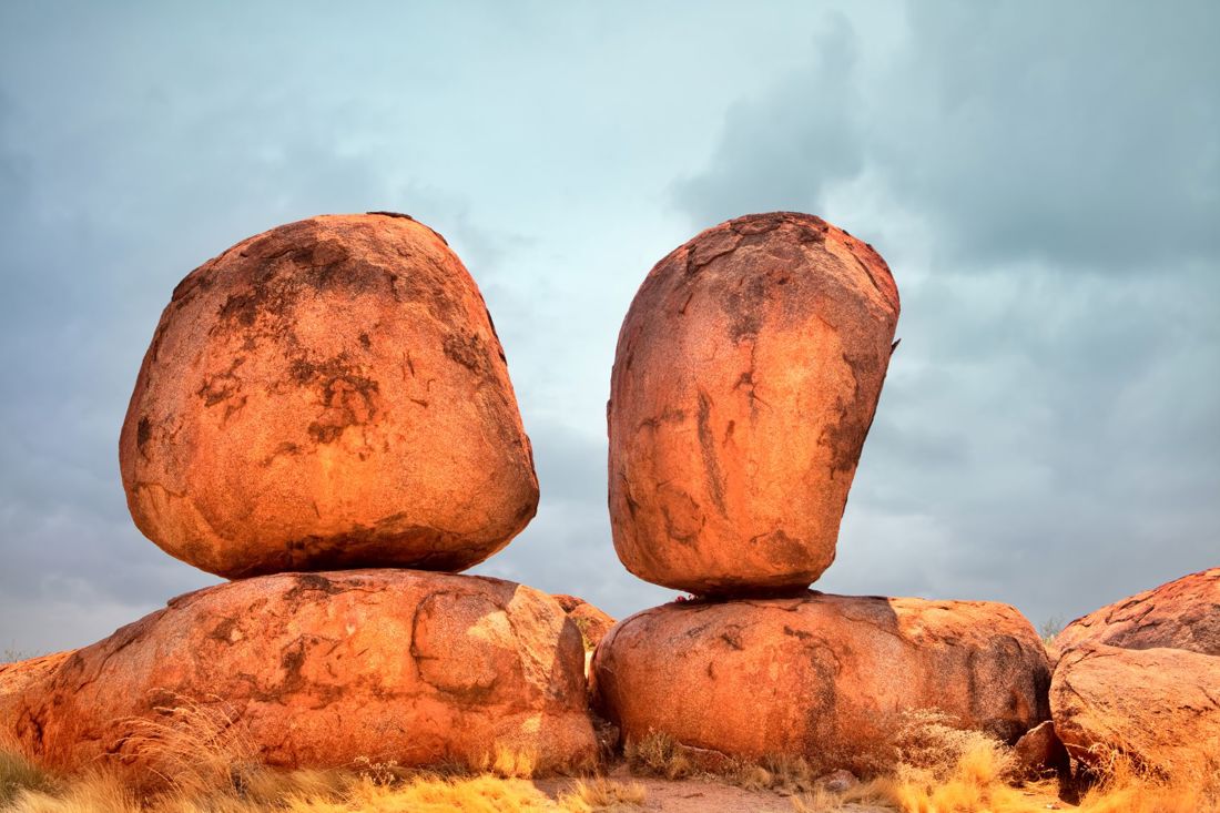
Karlu Karlu (Devils Marbles): Balancing Rocks of the Outback
Unusual Formations
Karlu Karlu consists of large, rounded granite boulders that appear to defy gravity.
Geological Background
The boulders formed 1.7 billion years ago through weathering of granite and laterite decomposition.
Cultural Beliefs
For the Warumungu, Kaytetye, Alyawarra, and Warlpiri people, they are sacred sites.
Height and Size
Some marbles are up to 6 meters in diameter, scattered across a wide valley.
Conservation Measures
Designated as a protected reserve since 1961, it helps preserve these unique Australian geological formations.
Bungle Bungle Range: Beehive Domes of Purnululu
Striking Appearance
The Bungle Bungle Range in Western Australia features orange and black striped sandstone domes.
Formation Period
Formed over 350 million years ago, the domes result from erosion of river sediments.
Remote Beauty
Located in Purnululu National Park, it was only widely known in the 1980s.
Aerial Tourism
Scenic flights offer bird’s-eye views to over 30,000 visitors annually.
UNESCO Status
It was added to the World Heritage List in 2003, recognizing it as one of the most spectacular Australian geological formations.
Kata Tjuta: The Olgas’ Multi-Domed Majesty
Multiple Domes
Kata Tjuta features 36 domed rock formations spread across 20 square kilometers.
Geological Composition
Unlike Uluru’s uniform sandstone, Kata Tjuta consists of conglomerate rocks formed over 500 million years ago.
Anangu Significance
It holds spiritual meaning for the Anangu, particularly in Men’s Dreaming stories.
Erosion and Shape
Water and wind erosion have shaped these domes into smooth, rounded forms.
Visitor Access
More than 250,000 tourists explore this site each year, gaining insight into diverse Australian geological formations.
From Sandstone to Seafloor: The Diverse Geology of Australia
Flinders Ranges: Fossils and Folded Mountains
Oldest Fossils
The Flinders Ranges are home to the 600-million-year-old Ediacaran fossils, among the oldest complex life on Earth.
Tectonic Origins
Formed by folding and uplift caused by the Adelaide Geosyncline, the ranges stretch over 430 kilometers.
Fossil Discoveries
Fossils like Dickinsonia have helped redefine the history of evolution.
Geotourism Appeal
Attracting over 120,000 visitors annually, it’s a hotspot for geological and scientific tourism.
Heritage Conservation
These Australian geological formations are part of the proposed World Heritage listing for fossil preservation.
Nullarbor Plain: The World’s Largest Limestone Karst
Geographic Vastness
Covering 200,000 square kilometers, the Nullarbor Plain stretches across South and Western Australia.
Karst Features
Its landscape includes sinkholes, blowholes, and over 150 known caves.
Paleoclimatic Data
Speleothems in the caves provide climate records dating back over 500,000 years.
Roadside Attraction
The Eyre Highway crosses the plain, drawing thousands of cross-country travelers annually.
Flora and Fauna
Home to 390 species of vascular plants and over 180 bird species, it’s a living geology museum showcasing Australian geological formations.
Blue Mountains: Sandstone Plateaus and Cliff Faces
Layered Sandstone
Formed over 300 million years, the Blue Mountains consist of Triassic sandstone and quartzite.
Erosion Features
Deep gorges and escarpments were carved by rivers like the Grose and Coxs.
Three Sisters
This iconic rock formation rises 922 meters above sea level, attracting 4.2 million tourists annually.
World Heritage Site
Listed in 2000 for its biodiversity and dramatic landscapes.
Scientific Importance
The region illustrates the interplay of tectonics and climate on Australian geological formations.
Tasmania’s Dolerite Peaks
Columnar Formations
Tasmania has the world’s largest concentration of Jurassic dolerite columns, seen at Mount Wellington and Organ Pipes.
Cooling Process
Dolerite formed 180 million years ago from molten rock cooling slowly into columns.
Unique Ecosystems
The cool, wet climate supports alpine species found nowhere else in Australia.
Tourist Draws
Over 1.3 million visitors annually explore its national parks.
Geological Significance
These dolerite cliffs highlight the diversity within Australian geological formations.
Great Dividing Range: Backbone of the Eastern Coast
Massive Extension
Stretching over 3,500 kilometers, the Great Dividing Range is Australia’s longest mountain range.
Geological Complexity
It includes sedimentary, volcanic, and metamorphic rocks spanning over 300 million years.
Rain Catcher
The range affects rainfall patterns, with eastern slopes receiving over 2,000 mm annually.
Biodiversity Corridor
Home to 70% of Australia’s plant and animal species, the range is ecologically vital.
Human Settlement
Major cities like Brisbane and Sydney developed along these key Australian geological formations.
MacDonnell Ranges: Folds of Central Australia
Ancient Origins
The MacDonnell Ranges formed over 300 million years ago during the Alice Springs Orogeny.
Structural Features
They showcase synclines, anticlines, and folded quartzite ridges.
Desert Biodiversity
Despite arid conditions, over 600 plant species and 200 vertebrates live here.
Tourism Statistics
Alice Springs and nearby gorges attract around 400,000 visitors per year.
Cultural Context
They are part of Indigenous songlines, giving cultural meaning to these Australian geological formations.
Cape York Volcanic Fields
Volcanic Heritage
Cape York hosts more than 50 small volcanoes, some as recent as 8,000 years old.
Basaltic Lava Flows
The landscape includes extensive lava plains and crater lakes like Lake Eacham.
Biological Hotspot
The volcanic soil supports dense rainforests and unique wildlife.
Geological Monitoring
Geoscience Australia monitors this region for future activity.
Tourist Appeal
Though remote, the volcanic fields enrich understanding of Australian geological formations.
Australia’s Ancient Earth: Exploring Timeless Landforms
Hamersley Range: Iron-Rich Layers from Earth’s Youth
Geological Antiquity
The Hamersley Range in Western Australia includes rocks over 2.5 billion years old, making it one of the oldest known Australian geological formations.
Iron Ore Deposits
This area produces over 760 million tonnes of iron ore annually, comprising more than 60% of Australia’s iron exports.
Formation Process
Composed mainly of banded iron formations (BIFs), the rocks resulted from ancient oceanic processes and early microbial life.
Mining and Economy
Mining hubs like Tom Price and Newman are central to Australia’s economy, contributing $136 billion to GDP in 2023.
Ecological Value
Despite industrial activity, the range houses endangered species such as the northern quoll and Pilbara olive python.
Coober Pedy: Opal Capital with Underground Geology
Famous Opal Fields
Coober Pedy supplies over 70% of the world’s opals, forming in silica-rich sandstone around 100 million years ago.
Underground Living
Due to harsh surface temperatures, many residents live in dugouts carved into the rock, utilizing Australian geological formations for shelter.
Fossil Discoveries
Marine fossils, including ancient plesiosaurs and giant ammonites, are common due to the area’s prehistoric seabed.
Tourism Economy
Around 150,000 tourists visit annually to see the opal mines and unique subterranean homes.
Climate Adaptation
The underground lifestyle showcases how humans adapt to geology in extreme environments.
Wolfe Creek Crater: A Meteoric Impact Frozen in Time
Celestial Origin
Wolfe Creek Crater, located in Western Australia, spans 875 meters in diameter and formed about 120,000 years ago from a meteorite impact.
Geological Structure
The rim rises 25 meters above the desert, revealing a near-perfect circular shape.
Scientific Studies
The crater helps researchers understand planetary impacts and Earth’s geological resilience.
Cultural Lore
Aboriginal stories describe it as the place where the Rainbow Serpent emerged from the ground.
Visitor Numbers
Although remote, the site receives approximately 20,000 visitors annually intrigued by such rare Australian geological formations.
Kings Canyon: Vertical Cliffs and Garden of Eden
Sheer Escarpments
Located in Watarrka National Park, Kings Canyon features 100-meter-high sandstone cliffs formed 400 million years ago.
Erosion and Weathering
The canyon formed through uplift and erosion of the Mereenie sandstone over millions of years.
Biodiversity Niche
The sheltered Garden of Eden houses over 600 plant species, including ancient cycads.
Tourist Trail
The 6 km Rim Walk is a popular track, drawing 300,000 visitors annually.
Sacred Landscape
Traditional owners, the Luritja people, view the canyon as a spiritual landmark shaped by Australian geological formations.
Lake Eyre Basin: Inland Sea Turned Salt Flat
Gigantic Drainage System
The Lake Eyre Basin spans over 1.2 million square kilometers and covers one-sixth of the Australian continent.
Salt Crust Phenomenon
Kati Thanda–Lake Eyre occasionally floods but remains a vast salt flat most years due to high evaporation rates.
Sediment Records
Core samples reveal sedimentary layers dating back 200 million years, crucial for climate studies.
Avian Influx
In flood years, up to 200,000 pelicans and other waterbirds gather, supported by the basin’s geology.
Ecological Challenges
Managing this dynamic region remains key to preserving unique Australian geological formations and habitats.
Naracoorte Caves: A Fossil Vault Beneath Limestone
World Heritage Fossils
Located in South Australia, Naracoorte Caves hold over 500,000 years of fossil records from the Pleistocene Epoch.
Speleothem Beauty
The caves display stalactites, stalagmites, and flowstones formed through calcium carbonate precipitation.
Excavation Sites
Over 130 fossil species have been discovered, including extinct marsupials like Diprotodon.
Educational Tourism
Receiving more than 75,000 visitors annually, the caves serve as a window into Australia’s past.
Geological Preservation
Their limestone chambers make them vital for understanding climate evolution and Australian geological formations.
Grampians: Sandstone Ranges with Indigenous Heritage
Tectonic Activity
The Grampians were formed over 400 million years ago during the Devonian Period through tectonic compression.
Erosional Features
Layered sandstone cliffs, escarpments, and gorges define its topography.
Cultural Rock Art
More than 80% of Victoria’s known Aboriginal rock art is found here, deeply tied to the landforms.
Biodiversity Haven
Home to over 1,000 plant species, including 20 endemics, it is a floristic hotspot.
Recreational Hub
Over 1 million visitors explore the area annually, often unaware they are walking through ancient Australian geological formations.
Beneath the Surface: Uncovering Australia’s Geological Secrets
Great Artesian Basin: Subterranean Water Reservoir
Largest Aquifer
The Great Artesian Basin spans 1.7 million square kilometers and holds 65,000 million megaliters of water beneath ancient sedimentary rock layers.
Geological Formation
It formed during the Jurassic and Cretaceous periods, trapping water between permeable sandstone layers.
Agricultural Lifeline
Over 180,000 bores have been drilled to access water, supporting rural communities and livestock industries.
Water Temperature
Water emerging from the basin can reach temperatures up to 100°C, used in spa tourism and geothermal energy.
Environmental Focus
Modern management aims to balance extraction with conservation of Australian geological formations tied to groundwater systems.
Mount Gambier: A Dormant Volcanic Complex
Last Eruption
Mount Gambier last erupted 4,600 years ago, making it one of Australia’s youngest volcanoes.
Blue Lake
Its crater houses the striking Blue Lake, which changes color seasonally due to mineral concentration and sunlight.
Lava Tubes
The surrounding region features lava tunnels and sinkholes formed by basaltic flows.
Tourist Favorite
Over 100,000 people visit annually, with the lake and caves being key attractions.
Seismic Research
Geologists monitor the region for potential future volcanic activity, emphasizing the relevance of Australian geological formations.
Glass House Mountains: Volcanic Remnants in Queensland
Iconic Peaks
Formed 25 million years ago, these mountains are the cores of extinct volcanoes, with peaks like Mount Beerwah rising 556 meters.
Composed of Trachyte
Unlike basaltic volcanoes, these are trachyte plugs, harder and more resistant to erosion.
Aboriginal Significance
The Jinibara people consider them sacred, with stories explaining their formation and names.
Protected Area
Part of the Glass House Mountains National Park, protecting over 100 plant species.
Hiking Destination
More than 200,000 people explore these Australian geological formations annually through scenic trails.
Jenolan Caves: Underground Marble Marvel
Oldest Caves
Dating back 340 million years, Jenolan Caves are among the oldest open caves in the world.
Limestone to Marble
The caves are composed of limestone transformed into marble through heat and pressure.
Rich Decoration
Features like the “Broken Column” and “Helictite Crystal” draw over 250,000 visitors per year.
Subterranean Ecosystems
Blind cave beetles and shrimp show how life adapts to complete darkness.
Scientific Legacy
Continuous exploration makes it a key research site for Australian geological formations.
Warrumbungle Volcano: Australia’s Only Dark Sky Park
Volcanic Remnant
The Warrumbungles formed from volcanic activity 17 million years ago, now eroded into spires and domes.
Siding Spring Observatory
Located here due to low light pollution and stable land, the observatory benefits from the region’s geology.
UNESCO Status
Declared a Dark Sky Park in 2016, attracting thousands of astro-tourists annually.
Unique Formations
Breadknife, a 90-meter-high volcanic dyke, is a rare geological phenomenon.
Wildlife Refuge
Despite 2013 bushfires, over 120 bird species and numerous marsupials survive, making it a living example of resilient Australian geological formations.
Cape Raoul Sea Cliffs
Vertical Columns
Located in Tasmania, Cape Raoul’s cliffs rise 300 meters above the Southern Ocean, formed from Jurassic dolerite.
Geological Columns
The vertical columns are a result of slow magma cooling and fracturing.
Trekking Attraction
The 14-kilometer trail to Cape Raoul sees over 50,000 hikers yearly.
Whale Watching Spot
Migrating humpback and southern right whales are often spotted near the base of the cliffs.
Climate Impact
The harsh coastal erosion continues to shape these stunning Australian geological formations.
Cape Le Grand Granite Outcrops
Old Crystalline Rocks
Granite hills like Frenchman Peak formed 1.6 billion years ago and have survived immense weathering.
Smooth Domes
Rounded rock outcrops dot the landscape, providing a scenic contrast to white sand beaches.
Biodiversity
Over 180 plant species and rare wallabies inhabit this national park.
Tourism Growth
Visitor numbers increased by 12% in 2023, totaling around 90,000, drawn by both beauty and geology.
Geological Highlights
These smooth domes are among the oldest exposed Australian geological formations still accessible today.